


Latitude and longitude are a geographic coordinate system used to help locate and chart places on a spherical globe. Longitude is measured as the distance east or west of the Prime Meridien in Greenwich, London. The maximum longitude is 180 degrees east and 180 degrees west meaning they meet at their furthest points, the International Date Line (note, the International Date Line is not a true straight line as it has been manipulated for political and economic reasons.) This means if you stepped, or more likely swam, across this imaginary line not only would you gain or lose a day you would have travelled from 180 degrees west to 180 degrees east in a short distance. Thankfully the purpose of this scoring system that area of the world is very hard to reach. This phenomenon also occurs at the North and South poles where the Meridians merges, again not an easy place to reach! For a more detailed description on Longitude see this excellent National Geographic article.

There were a number of reasons in 1884 that Greenwich was chosen to be 0 degrees longitude. The first was the fact that the USA had already chosen Greenwich as the basis for its own national time zone system. The second was that in the late 19th century, 72% of the world’s commerce depended on sea-charts which used Greenwich as the Prime Meridian. The British Empire’s global influence also had a major factor on the decision too.

So to the game. In order to calculate your Travel Wingspan you need to add the furthest longitude east you have ever been together with the furthest longitude west. For example for myself the furthest west of the prime Meridien I have been is 122.7141° W at Santa Rosa, California (for the purposes of this game we will always round down) so 122W. The furthest East was Rotorua in New Zealand at 176.2378 (176E). Therefore my travel wingspan is a total of 298, from a maximum of 360, so not too bad. Using the category table (below) this places me in the Antonev AN-225 category.

A little bit more detail on the calculation rules. This is more suited to European followers of the blog, if you happen to live in North America or Australasia for example you will have a distinct advantage with potentially a 100 degree head start. More so you if live close to the International Date Line, you may simply have to make a short (boat) journey to gain the maximum score of 360! Also the definition of your furthest point is where you have visited ON LAND, so flying over the international date line does not count and neither do airport transits.
So when you have worked out your wingspan send your total in, together with the 2 places used to get to that score and I will add it to the table. Let’s see if you are a Cessna or a Stratolaunch!

UPDATED TABLE AS OF 06DEC20!!!
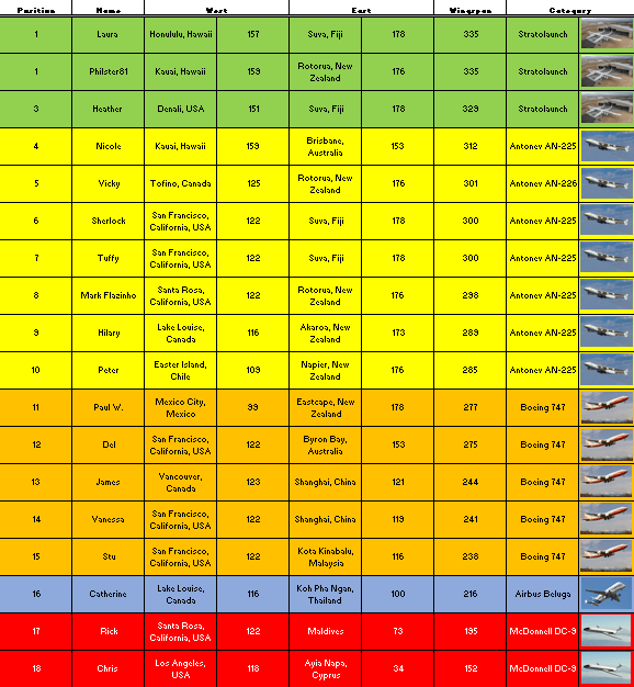

Stratolaunch for me and Mr H with 335 (178E for Suva and 157W for Honolulu)
Great work as always Flaz
LikeLiked by 2 people
very impressive, that’ll be hard to beat I think
LikeLike
Kauai, Hawaii – 159W
Rotorua, New Zealand – 176E
= 335
LikeLike
Nice one Philster, I’ll update the list, that score will put you in joint 1st place with Laura!
LikeLiked by 1 person
Great, thanks Flaz
LikeLike
Kauai, Hawaii – 159W
Brisbane – 153E
= 312
thanks, Nicole
LikeLike
Tofino and Rotorua… put me on the table! 🙂
LikeLike
Thanks for the submission Vicky, let me calculate those and get the table updated
LikeLike